


Sea floor images now available to all!
Have you ever wondered what the sea floor looks like off the NSW coastline?
Thousands of images of the NSW sea floor have just been made publicly available online.
Researchers, ocean enthusiasts and members of the public can now view over 11,000 images of the sea floor along the NSW coast captured by NSW Marine Estate Management Strategy scientists.
It is all part of a project to track the impact of climate change on marine habitats in NSW.
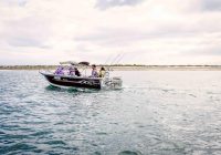
Department of Primary Industries – Fisheries Scientist Dr Tom Davis spent weeks at sea collecting the photos using a submerged camera towed behind a boat.
He said as well as helping Fisheries track the effects of climate change on rocky reef habitat across our coast, the undersea photos will be used by other researchers and ocean enthusiasts.
“It’s fantastic we can get this imagery out there so everyone can benefit,” Dr Davis said.
“These images are not just for researchers and universities. They are for anyone keen to discover what is off your bit of coast. Accessing underwater areas is not easy, so now anyone can get online and find out what’s out there,” he said.
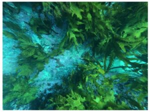
“If you go to the SQUIDLE+ website, you can see the images taken at differing locations along the NSW coast. For instance, off Eden you can see areas of kelp, urchin barrens and sponge gardens. Whereas up off Tweed Heads there are diverse coral gardens and algal beds to check out.”
The photo surveys will be repeated every few years to help track how climate change is affecting our coastal habitats.
The images can be viewed on the SQUIDLE+ website by selecting ‘NSW DPI Towed Camera’ in the ‘Filter by Platform’ pull-down menu.
Mapping the sea floor is part of the Marine Estate Management Strategy Climate Change Monitoring project. The images have been made available through collaboration with the IMOS Integrated Marine Observing System through their Understanding Marine Imagery program.