


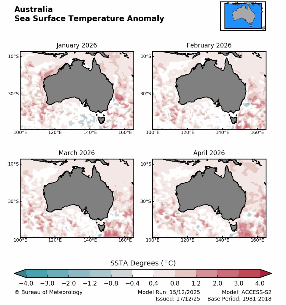
Australians can now access free long-range marine heatwave (MHW) forecasts on the Bureau of Meteorology’s Long-range ocean forecasts pages, providing guidance on the likelihood, location and predicted severity of marine heatwaves around Australia up to four months ahead.
A marine heatwave is a period of sustained extreme ocean temperatures, when ocean temperatures in a location are warmer than usual for the time of year for a defined period. These conditions can harm marine ecosystems and affect habitats, threatened species, fisheries, aquaculture, marine parks and other ocean activities that depend on healthy oceans.
The new service was developed through a research collaboration between the Bureau of Meteorology and CSIRO, with funding support from the Australian Government Department of Climate Change, Energy, the Environment and Water (DCCEEW), the Fisheries Research and Development Corporation (FRDC) and CSIRO. The forecasts build on four years of research using the Bureau’s ACCESS-S2 seasonal prediction system and have been tested with industry through national marine climate briefings and broader stakeholder engagement.
The launch was announced by the Minister for Environment and Water and the Minister for Agriculture, Fisheries and Forestry in a joint media release.
Minister for the Environment and Water, Murray Watt said greater forecasting will help Australia to prepare for water temperature events in the future.
“Marine heatwaves were listed as a key hazard in the National Climate Assessment, and we expect them to become more common due to climate change,” Minister Watt said.
“Recent extreme marine heatwave events have had serious impacts on ocean health, protected species, and fisheries and aquaculture operations in Australian waters, including mass fish kills, low fishery yields, and contributing to algal blooms.
“These outlooks will step beyond monitoring and will aim to forecast potential issues before they eventuate.”
Recent summers have underscored the urgency of improved outlooks. Australia’s ocean was the warmest on record in 2024–25, with widespread marine heatwaves contributing to coral bleaching on the east and west coasts, fish kills in Western Australia, and harmful algal blooms in South Australia.
Minister for Agriculture, Fisheries and Forestry, Julie Collins said industry would particularly benefit.
“This information will be made publicly available so that the fishing and aquaculture industry can make informed decisions about their operations or their catch, based on what conditions may look like later in the season,” Minister Collins said.
“This is not only important for long-term business viability, but also impacts Australia’s food security and the national economy.”
As well as helping marine users and governments prepare and adapt operations, the Bureau says the outlooks can support planning for surveys, briefings and research into the impacts of ocean warming and future adaptation options for marine environments.
Forecasts will be updated three times each week and presented in two sets of regional maps, showing the probability of a marine heatwave occurring and the category of marine heatwave (none, moderate, strong, severe or extreme). The Bureau notes that the category framework is a useful and intuitive way to communicate extreme ocean temperatures, based on engagement with decision-makers across fisheries and state agencies.
Marine heatwaves are considered a key hazard in the National Climate Risk Assessment and marine heatwave information is now a critical component for state-based marine heatwave response plans. The Bureau says the new capability represents a major step forward in supporting resilience for Australia’s marine industries and ecosystems in a warming climate.
For more information visit www.bom.gov.au/coastal-location/australia