


Long days, difficult weather and almost 900 kilometres of coastline between sites.
That’s what scientists from the Department of Climate Change, Energy, the Environment and Water and CSIRO were up against on their recent quest to develop “spectral profiles” of coastal waters for NSW.
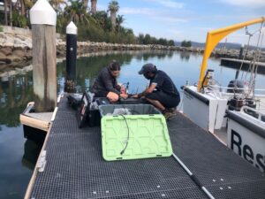
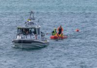
Gemma Kerrisk and Nagur Cherukuru (CSIRO) setting up sensors to be measure spectral signatures and in-water properties from DCCEEW research vessel Badoo, Batemans Bay (Photo: Tim Ingleton).
The team just spent several weeks measuring water quality and light properties of water in the Clyde, Manning and Richmond Rivers and adjacent oceans, to gather the data required so they can track our coastal water quality from afar.
The fieldwork is all part of a push to improve our understanding of how water coming from our rivers during flood events impacts our oceanic water quality.
But why would scientists be getting out on the water to measure … light? What can light measurements in water tell us?
Well, according to DCCEEW Research Scientist Dr Tim Ingleton, quite a lot.
“Once we have these spectral profiles for the different rivers, algorithms will be developed that can map the extent of poor water quality due to flooding using satellite data,” he said.
He says this work will completely revolutionise the way we measure water quality in our coastal waterways.
“Up until recently, if we wanted to determine water quality of an area, we had to physically go and collect water samples. This limits how often we can measure water quality of our waterways,” Dr Ingleton said.
“Using this system, we will be able to track water quality for the most part using satellite data, only having to have physical water quality samples occasionally to ensure the algorithms are accurate,” he said.
“This is a massive change and will help us better predict and manage our coastal waterways into the future,” Dr Ingleton said.
Dr Ingleton says measuring and understanding these freshwater outflows from flood events is essential to understanding the ecology of the NSW coast.
“As well as delivering nutrients, carbon and other food sources to our marine environment, freshwater outflows can also contain sediments, which may be natural, or may contain pollution and fertiliser,” he said.
“The amount of sediment, fertiliser and other pollutants in the oceans affect everything living in the ocean, from tiny marine critters to fish.”
“This innovation will help us understand the movement of nutrients and sediments from rivers out to the ocean during flood events and how long they persist in the water column.”
“The knowledge gained through this project is essential to help better manage the water quality of our coastal waters into the future,” Dr Ingleton said.
This work is part of the Coastal Outflows project and funded via Marine Estate Management Strategy Initiative 1: Improving water quality outcomes.