


Article by Hans Buitelaar, METSTRADE
Data collection and machine learning for safety and conservation
Navigational instruments can be programmed to upload data to a cloud service. Industry association NMEA started NMEA cloud to analyse typical activities of leisure boating and use this data set to improve safety. Computers can learn where dangers occur and help boaters to avoid those. Forward looking camera’s, fish finders and a new A.I. driven radar signal interpretation device have been developed to help avoid collisions directly on board, by first hand observation.
The U.S. based National Marine Electronics Association calls for manufacturers and boaters to participate in the testing phase of their NMEA Cloud. The marine instrument connectivity protocol that this association has developed, has become a worldwide standard. Working with marine ecosystem protection organisations, NMEA developed the idea of collecting data from boats and yachts and build a database for marine biologists to study and in the same time use this data to increase boating safety. A.I. or advanced logarithms are used to analyse the information provide from participating yachts.
In-water object warning
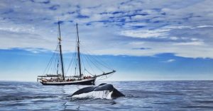
The risk of open water collisions with whales or other marine mammals or floating objects is threatening for oceangoing sailors. Austrian company SEA.AI developed a tool that uses thermal and optical sensors that detect floating objects like containers that have fallen off ships and float invisibly just under the surface. The sensors are connected to a computer that is self-learning and uses artificial intelligence to determine whether determined reflections or objects in the water pose danger or not. The screen with the SEA.AI set shows an augmented reality presentation on a screen that alerts the helmsman of unseen dangers ahead.
A.I. understands radar
SEA.AI is now collaborating with U.S. company Tocaro Blue. They launched Proteus Hub, that analyses radar signals. With radar, signals return from object that reflect the beams sent by the rotating antenna. It is up to the navigator to make sense of the series of objects detected, and see if the dots on the screen are just reflections from waves or rocks before the bow. The Proteus Hub will learn b using A.I. how to interpret the signals and provide an augmented reality vision on the radar screen. The co-oparation with SEA.AI creates an all-round detection and warning system. Data from these systems can be automatically uploaded to the NMEA Cloud. It can also be used for warning maritime authorities or issuing alarm.
All yachts
But not only data from these rather advanced systems may prove valuable for the NMEA Cloud. Almost every yacht on open water has a set of interconnected instuments that collect data. This normally stays on board. Integrated yacht instruments for speed, windforce and direction, water depth, geographic position, engine monitoring and battery status have become standard on today’s yachts. All this information can be viewed via a multi function display that includes a digital chart.
Skippers and some yards add internet connections to their integrated instrument system to be able to monitor the status of their yacht remotely. AIS shares information about course, speed and destination with other ships and the world wide web for anybody to find the location of the yacht. Forward looking camera’s with daylight and night vision properties, combined with depth sensors – usually referred to as fish finders – have been added to the yacht’s range of instruments as aids for mid-water collisions with floating objects.
Machine learning through algorithms or artificial intelligence can detect possible dangers and warn the navigator. Earlier this year, the Proteus Hub smart box was introduced that can analyse radar signals and share the analysed information with other instruments to raise awareness about objects detected in the yacht’s surroundings. All of these instruments help the skipper to acquire greater situational awareness.
Data protocols
Connections that enable nautical instruments to share their information usually benefit from the international data protocols as introduced by NMEA. The National Marine Equipment Association from the U.S. introduced the ASCII based NMEA 183 protocol in 1983 and created the updated version NMEA 2000 in 2001. NMEA 2000 is CAN-bus based connection system in which all kinds of instruments can be connected, sharing all the information their sensors have detected. Additional to the NMEA protocols, some instrument manufacturers maintain their brand-specific data sharing systems like SeaTalk, SimNet or NKE Topline. These are often comparable to the NMEA protocol and can be connected to it through an interface. The plugs do not fit directly.
Whale protection
The Cloud initiative that NMEA is now starting, originated in 2024 from a co-operation of the Whale & Vessel Safety Taskforce (WAVS) as an effort to protect marine mammals, in particular the North Atlantic Right Whale. Reports of collisions of vessels and whales are still increasing. The exact location of such collisions and the time they occur, may provide valuable data to gain insight in the routes that these whales follow, the times they are moving and other particulars of typical behaviour of whales and other marine mammals. If not only the skippers would report their experiences with sightings and collisions with these animals, but the exact data from their instruments would be recorded, marine mammal behaviour could be better predicted and collisions might be avoided.
Warnings could be issued and marine protection areas could be established. Understandably, such collisions are not only hurtful or fatal for whales and dolphins and other mammals, these encounters are potentially very dangerous for pleasure boaters on their yachts. Sailing in to these large creatures at speed can seriously damage a yacht. The idea for anonymised data collection was born.

Anonymous data transmission
The industry association emphasises that all collected data will be anonymous and only serve to build a database of marine mammal encounter with yachts in specific areas. Data would be automatically collected and sent to the NMEA Cloud provided the vessel has higher bandwidth connectivity via satellite or near shore cellular. A maritime data ecosystem will grow.
This data set will be accessible by instrument manufacturers that can load the data into navigational devices, protecting their boating clients from dangerous collisions. Data collected from this effort can also serve academic research and marine conservation organisations around the world to better protect marine life.
The NMEA Cloud initiative is at the start of its testing phase. For more information or registering as participant, take a look at the NMEA website: https://www.nmea.org/nmea-cloud.html