


Advanced Navigation, a leader in navigation and autonomous systems, in collaboration with marine consultancy O2 Marine, has revealed an explicit visual depiction of Hall Bank – a small, nearshore reef off Fremantle in south-west Australia (32°S), located well beyond the typical latitudinal range for coral reefs.
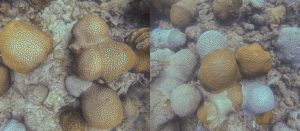
Using Hydrus, a micro hovering autonomous underwater vehicle (AUV), the teams conducted a detailed survey of the reef, capturing geo-referenced high-resolution imagery and 4K video in parallel. The data showed severe coral bleaching and fragmentation, laying bare a hidden yet escalating crisis at one of the world’s southernmost reefs.
Bringing Affordable Insights to the Surface
O2 Marine’s ambition lies in aiding businesses to accelerate efforts in marine environmental assessment and monitoring, marine fauna, and oceanography. This necessitates the use of advanced technology to collect data and insights for knowledge-sharing in a cost-effective way.
“To truly understand the extent of coral bleaching, we need high-resolution, spatially accurate data that captures both the scale and the fine detail of change beneath the surface,” said Claudio Del Deo, Co-Managing Director at O2 Marine.
The data gathered from Hydrus was used to generate a 3D digital twin of the Hall Bank seabed. The model revealed a barren seafloor filled with pale, lifeless corals, documenting the shrinking coral formations.
This comes at a time when both of Australia’s two world heritage-listed reefs—Ningaloo and the Great Barrier Reef—were simultaneously hit by coral bleaching in March 2025, driven by an intense marine heatwave that drove sea surface temperatures up to 4°C above the summer average.
“Unlike traditional underwater vehicles, Hydrus’s compact design, fleet deployability, and ability to gather professional grade data allow us to monitor reefs at a scale and frequency previously unattainable. This level of detail is essential for informing conservation strategies and building the baseline needed for long-term reef recovery,” added Del Deo at O2 Marine.
As we expand our conservation efforts globally, Hydrus is proving to be an indispensable part of our toolkit, enabling actionable insights that will guide both immediate responses and future restoration.”
Hall Bank – a Natural Underwater Lab
The Hall Bank site – regarded as a rare and valuable example of high-latitude reef resilience[1] – was an ideal deployment area for Hydrus. Its ability to support extensive coral cover in cold, turbid waters makes it a vital natural lab for studying climate adaptation. Hosting a unique mix of tropical, subtropical, and temperate coral species, it offers critical insights into species range shifts and reef development under changing ocean conditions.
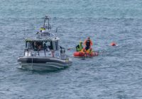
The mission involved the simultaneous deployment of three Hydrus units, each executing coordinated transects and lawnmower survey patterns across different sections of the reef.
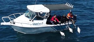
O2 Marine and Advanced Navigation deploying three Hydrus units at Hall Bank
This approach enabled comprehensive spatial coverage, ensuring overlapping, high-resolution data capture across the site. By flying precise, parallel tracks, Hydrus was able to systematically map the reef’s structure and condition, capturing the fine-scale changes in coral health that are often missed by traditional survey methods.
Speaking to the mission’s success, Alec McGregor, Senior AI Engineer at Advanced Navigation, said:
“Collecting high-quality ocean data has traditionally been slow, costly, and resource-intensive, where sending divers or ROVs below 50 metres in depth can run into tens or even hundreds and thousands of dollars. That simply doesn’t scale, especially when time-sensitive data is needed across large or remote areas.
Hydrus changes the equation. At just 7kg, it can be deployed by a single person, without the need for support vessels or complex logistics. This mission is a powerful example of what’s possible when cutting-edge robotics meets urgent environmental challenges. Hydrus puts critical data into the hands of scientists and marine operators faster, more safely, and more affordably – enabling smarter, more timely decisions for conservation and climate adaptation”.
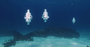
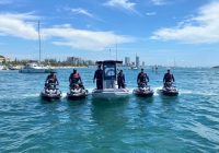
Micro hovering AUV Hydrus operating as a fleet at Hall Bank
Continuing to Drive the Drone Revolution Underwater
Today, ocean temperatures continue to rise, mass coral bleaching events are becoming more frequent. Yet only 26.1% of the ocean floor has been explored.
To unlock the ocean’s mystery and open it up for further scientific discovery, Advanced Navigation is appealing to the goals of the Seabed 2030 initiative and the overarching United Nations “Ocean Decade” development plan[6], by working with partners to map the ocean floor.
This mission builds on Hydrus’s growing track record of underwater discovery and documentation – from coral reefs to shipwrecks.
In 2024, Hydrus spotted a 64-meter shipwreck – more than twice the size of a blue whale, the largest marine animal – scattered across the seafloor in the Indian Ocean. Together with Curtin University HIVE, Advanced Navigation was able to rebuild a high-resolution replica of the wreck using the data gathered by Hydrus. The model now sits with the Western Australian Museum’s public archive, and can be seen in life-size form at the Curtin University HIVE on their immersive Cylinder display.
O2 Marine
O2 Marine is a boutique marine environmental and oceanographic consulting business with offices in Western Australia and Queensland. Since O2 Marine was founded in 2014, the team has quickly become one of the largest specialist marine consulting teams in Australia. An achievement that was recognised in November 2021, when O2 Marine was named in the Australian Financial Review as one of the TOP 100 fastest growing companies in Australia and O2 Metocean was named as in the Top 100 fastest growing start-ups in Australia.
For additional information, visit o2marine.com.au
Advanced Navigation
Advanced Navigation is a global leader in navigation and autonomous systems. By leveraging capabilities in software-enhanced hardware, every solution delivers unrivaled capabilities and exceptional performance across land, air, sea and space applications where GPS is unreliable.
Made possible with extensive research, testing and vertically integrated manufacturing, the company has progressed into deep technology fields, including robotics, inertial, photonic and quantum sensing, artificial intelligence, underwater acoustics, and GPS antennas and receivers. Customers choose Advanced Navigation for rapid product delivery and unmatched technical field expertise.
Headquartered in Sydney, Australia, with research and production facilities nationwide and offices globally. Advanced Navigation is an Australian manufacturer exporting worldwide. #JoinTheAutonomyRevolution
For additional information, visit www.advancednavigation.com